Geotrafo 4.5
Free Version
Publisher Description
Geotrafo - coordinate converter for various systems in the European area
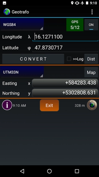
Geotrafo is used for coordinate transformation of various systems in the European area.
What coordinate systems does the app support?
https://www.geotrafo.com/data/App/Systemliste.htm
The conversion is done mathematically using the Helmert transformation.
In addition to the predefined parameters for the usual coordinate systems, you can also use your own parameters for the datum transformation, the projection and the ellipsoid.
Supported projections are Transversale Mercator, Lambert Conic 2SP, Stereographic and Cassini-Soldner.
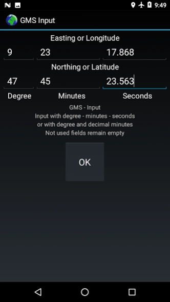
In geographic systems, the input and output can be in decimal degrees or degrees/decimal minutes or degrees/minutes/seconds.
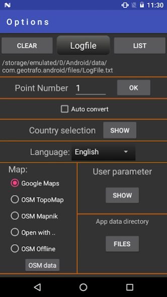
If the checkbox is selected, then the result of the conversion is also saved in a log file, everytime, when the CONVERT button is pressed.
For this log file there are import and export functions for the data formats Text, GPX and SHP. The saved points can be copied back into the input or output fields. The Logfile LogFile.txt can also be created externally and then copied or imported into the app-specific directory. The data is managed in the Options mask.
Here you can also select the map for the display of individual points. When using offline or online maps of Open Street Maps, you can also display all points of the coordinate list. With the OpenStreetMaps offline selection, the app uses ZIP files with OSMdroid data. The data can be created on the PC, for example, with the Mobac program. Alternatively, it is also possible to display the coordinates on another installed app.
The number of systems in the system selection boxes is reduced by preselecting the required countries.
With the Autoconvert function, the coordinates are converted automatically when the output system is changed or when the GPS is active when the input coordinate was updated.
The GPS can be activated on the main screen. In the satellite view, the satellite positions or data are list form is shown .
The expected accuracy and the PDOP/HDOP/VDOP values are displayed.
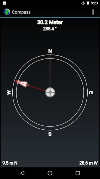
The compass is used to find points and calculate distances between input and output coordinates (regardless of the selected coordinate system). As an alternative to the orientation sensor, which is not always available, the GPS signal can also be used. (in the case of activ GPS always GPS compass is started). The distances are calculated in the x/y direction in different units, including the choice of any map unit KEH (= map scale). If GPS is activated, the values are constantly updated.
9 languages can be selected within the app.
(English,Deutsch,Français,Español,Čeština,Magyarul,Româneste,Hrvatski,Bosanski)
Required permissions: Location
(for using GPS)
You can find more information on the homepage
(https://www.geotrafo.com)
PDF: https://www.geotrafo.com/data/App/en/manual_app.pdf
About Geotrafo
Geotrafo is a free app for Android published in the System Maintenance list of apps, part of System Utilities.
The company that develops Geotrafo is pich. The latest version released by its developer is 4.5. This app was rated by 1 users of our site and has an average rating of 4.0.
To install Geotrafo on your Android device, just click the green Continue To App button above to start the installation process. The app is listed on our website since 2023-10-10 and was downloaded 87 times. We have already checked if the download link is safe, however for your own protection we recommend that you scan the downloaded app with your antivirus. Your antivirus may detect the Geotrafo as malware as malware if the download link to com.geotrafo.android is broken.
How to install Geotrafo on your Android device:
- Click on the Continue To App button on our website. This will redirect you to Google Play.
- Once the Geotrafo is shown in the Google Play listing of your Android device, you can start its download and installation. Tap on the Install button located below the search bar and to the right of the app icon.
- A pop-up window with the permissions required by Geotrafo will be shown. Click on Accept to continue the process.
- Geotrafo will be downloaded onto your device, displaying a progress. Once the download completes, the installation will start and you'll get a notification after the installation is finished.
